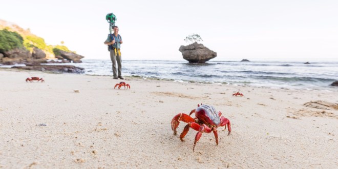
Google Earth and Streetview have been recording and sharing places off the beaten track like sheep in places around the world and one of its most popular recent shares was on Christmas Island.
Every year, the island which is governed by the Australian government, has thousands of crabs do their migration. Last year, Google recorded the annual migration of the Red Crab population.
The project was a collaboration between the Google Maps team and Parks Australia, who manage the migration of the estimated 45 million crabs every year. Parks Australia shut down roads and erecting fences to direct the crabs to safe crossing points including under-road passes, or fly-over bridges.
The imagery captured by Google was courtesy of the Trekker backpack, which was worn by Dr Alasdair Grigg, Parks Australia who said
Capturing the imagery of Christmas Island and the Cocos Keeling Islands with the Google trekker camera has been an amazing adventure, every step of the way. I think it’s fantastic that people can now get a virtual experience of these places- from the dense jungle teaming with wildlife and rugged coastline of Christmas Island, to the stunning white sandy beaches and aquamarine lagoon of the Cocos Atoll. The red crab migration, endemic birds, plants, fishes and other unique wildlife of these islands is very special; and I hope the imagery inspires people to protect these natural wonders, and fragile island ecosystems the world over
The red crab migration is a well known and spectacular annual event. Each year, around November/December, the normally land based Red Crabs migrate out of the lush rainforests down to the coast of the island to breed.